 An official website of the United States government.
 Official websites use .gov
A .gov website belongs to an official government organization in the United States.
Official websites use .gov
A .gov website belongs to an official government organization in the United States.
 Secure .gov websites use HTTPS
A lock or https:// means you’ve safely connected to the .gov website. Share sensitive information only on official, secure websites.
Secure .gov websites use HTTPS
A lock or https:// means you’ve safely connected to the .gov website. Share sensitive information only on official, secure websites.
In FY 2014, the U.S. IOOS Program (IOOS®), in partnership with NOAA’s Ocean Acidification Program, continued a multi-year Ocean Technology Transition project to advance science and technology and better enable decision making.
The Ocean Technology Transition project sponsors the transition of emerging marine observing technologies, for which there is an existing operational requirement and a demonstrated commitment to integration and use by the ocean observing community, to operational mode. Operational mode is defined as the actual application of the technology in its final form and under mission operations. Ocean Technology Transition is envisioned as a multi-year effort that transitions marine observing technologies to operations in a stepped, parallel, and scalable process that includes stakeholder engagement from industry, government, academia and others invested in the monitoring and assessment of the nation’s ocean and coastal regions.
Marine observation technologies include hardware and software platforms, sensors, and data transfer technologies that collect observations in the marine and Great Lakes environments. Transitioning marine observing technology to operations will result in improved ocean, coastal, and Great Lakes observing capabilities that are critical for helping us understand our ocean, coastal, and marine environments and improve environmental intelligence for environmental decision making.
As part of this effort during FY 2014, IOOS awarded five grants totaling $2.1 million to foster the transition of marine sensor and other advanced observing technologies to operations mode. Details on each of the five grant projects follow:
- Integrate the Imaging Flow CytoBot (IFCB)
The University of California Santa Cruz was awarded a three year grant to incorporate consistent and cost-effective observations of Harmful Algae Bloom (HAB) and phytoplankton composition into the San Francisco Bay monitoring program to use as a metric to support ecosystem assessments. The project will integrate the Imaging Flow CytoBot (IFCB) into existing USGS RV/Polaris vessel transects, onto a planned mooring in the South San Francisco Bay, and on existing piers and/or fixed platforms monitoring to evaluate the potential to replace or augment phytoplankton enumeration (traditional microscopy) and HPLC pigment analysis to monitor phytoplankton composition and HABs in the San Francisco Bay. Year 1 funding for this effort is $426,098.
Specific objectives of the project are:
- compare the Imaging Flow CytoBot to other methods (HPLC pigments, microscopy) used to characterize the phytoplankton community structure of the SFB;
- develop near-real-time phytoplankton enumeration for existing ship-based time-series, including automated identification of HAB organisms;
- integrate the IFCB into existing pier-based and fixed-platform monitoring efforts; and
- assess data quality, cost, and reliability from IFCB compared to traditional methods.
- Operational Ecological Forecasting of Harmful Algal Blooms in the Pacific Northwest using an Environmental Sample Processor
The University of Washington Applied Physics Lab was awarded a three year grant to develop an operational ecological forecasting capability for HABs in the Pacific Northwest. This project proposes to place an autonomous, robotic marine biosensor (i.e., the Environmental Sample Processor [ESP]), with tested technology, on a well-established mooring to detect Pseudo-nitzschia cells and domoic acid escaping from the offshore Juan de Fuca eddy bloom initiation site in near real-time. Year 1 funding for this project is $600,000.
The specific goals of this project are to:
- operationally deploy an ESP on an existing real-time offshore moored observatory in the Pacific Northwest;
- obtain reliable and quantitative observations of toxic Pseudo-nitzschia escaping from a bloom initiation site using the ESP;
- disseminate observations to end-users in near real-time to the APL server via an existing cellular modem;
- synthesize enhanced HAB forecasts using ESP data; and engage Tribal communities on seafood safety and advanced environmental monitoring through outreach, education, and training through workshops, internships, science camps,
- and the development of curriculum.
-
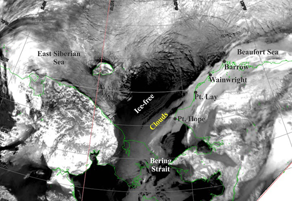
A Real-time Sensor System for Detecting Freeze-Up on Arctic Shelves.

November 24, 2013 AVHRR image illustrating the differences in ice cover on the East Siberian, Chukchi, and Alaskan Beaufort seas.
The University of Alaska Fairbanks was awarded a three year grant to develop and test an economical sensor package, using existing sensors in a new manner, which will be used operationally by a variety of stakeholders needing accurate predictions of the onset of fall ice formation. The proposed sensor system serves several purposes. First, it provides real-time data on the vertical temperature and salinity structure of the shelf so that agency permitting agencies and stakeholders, including the oil and gas industry and subsistence users, will know when offshore sea ice formation begins. Second, the data can be used to evaluate and refine NOAA and NWS sea ice forecast models (both existing models and those under development), which depend upon accurately predicting the seasonal evolution of the thermohaline structure of the ocean. Third, the data obtained from this sensor system could be useful in guiding remote sensing algorithms for frazil ice detection, a notoriously difficult process for remote sensing platforms.
The sensor package includes temperature/conductivity/pressure CTD recorders that record internally and transmit data (via a conducting wire) to a small surface buoy. The mooring will also have an acoustic release connected to an anchor and sub-surface flotation (positioned midway along the mooring wire). The surface buoy package will include a thermistor, a GPS sensor, and an Iridium communications system for transmitting the data to shore in real-time. The CTDs (deployed at nominal depths of 8, 20, 30 and 40 m) allow knowing when the entire water column is at the freezing point at which time further cooling will induce frazil ice formation. Year 1 funding for this effort is $161,905.
NERACOOS was awarded a three year grant to develop an integrated nutrient observatory within NERACOOS capable of resolving nutrient dynamics at temporal and spatial scales necessary to address critical needs of stakeholders throughout the Northeast region. Fifteen (15) Satlantic SUNA (Submersible Ultraviolet Nitrate [NO3] Analyzer) v2 sensors will be integrated on current NERACOOS mooring assets in western Long Island Sound, upper Narragansett Bay, Great Bay in New Hampshire, Massachusetts Bay, Penobscot Bay, 3 sites along the coastal shelf of the Gulf of Maine, at five depths in Jordan Basin in the interior Gulf, and at two depths in the Northeast Channel, between Georges and Browns Bank. In addition, ten (10) WET Labs’ nutrient sensors measuring phosphate will be deployed at the nearshore sites listed above. Each of these sites has specific environmental concerns with strongly invested stakeholders. Our goal is continuous, year round monitoring at all sites with a minimum six month servicing time period. Year 1 funding for this effort is $600,000.
In collaboration with NOAA’s Ocean Acidification Program, IOOS awarded the University of Washington Applied Physics Laboratory a three year grant to advance four new objectives regarding an ocean acidification (OA) observing system that addresses the needs of impacted and potentially vulnerable U.S. industries and stakeholders.
The project will develop and test three iterations of new, low-cost OA sensors. These instruments, will allow low-cost measurement of pCO2, temperature (T) and salinity (S), and ultimately pH and dissolved O2 (O2, aq) in a variety of deployment configurations. These will include small commercial fishing or tourist vessels, field moored locations, and autonomous free-drifting GPS-tracked and cell-phone-reporting systems. The project will also involve the development of best practices and QA/QC procedures in collaboration with NOAA’s Pacific Marine Environmental Laboratory; implementation of data flow to end users; and performing of outreach and education services to OA-impacted stakeholders. Year 1 funding for this effort is $318,000.
For more information about the Ocean Technology Transition project, please contact the Project Manager, Jenifer Rhoades at jenifer.rhoades@noaa.gov.