 An official website of the United States government.
 Official websites use .gov
A .gov website belongs to an official government organization in the United States.
Official websites use .gov
A .gov website belongs to an official government organization in the United States.
 Secure .gov websites use HTTPS
A lock or https:// means you’ve safely connected to the .gov website. Share sensitive information only on official, secure websites.
Secure .gov websites use HTTPS
A lock or https:// means you’ve safely connected to the .gov website. Share sensitive information only on official, secure websites.
CariCOOS Coastal Weather App (provided by CARICOOS)
 The CARICOOS Coastal Weather app provides users with an integrated view of ocean conditions in the US Caribbean, including real-time life buoy data (waves, wind and currents), as well as coastal Mesonet wind station data. It is designed as a tool for surfing, boating, fishing, sailing, and marine operations.Includes all US Caribbean coastal regions (Puerto Rico and US Virgin Islands).
Download for: Android
Northwest Pacific Data on the Go App (provided by NANOOS)
 The NVS Assets App provides easy access to data on-the-go in the field or on the water. It displays data from federal, tribal, state, academic, industry, and non-profit organizations, who operate a wide variety of observing assets including buoys, shore stations, sea-bed, and coastal land-based stations. This composite view provides a comprehensive view of ocean conditions.
Data Explorer App and Tsunami Evacuation App (provided by NANOOS)
 TsunamiEvac-NW provides at-a-glance view of where the tsunami hazard zones are along the Oregon and Washington coast, and allows to map whether your home, work, school, etc. is located in a tsunami evacuation zone or not. To help develop and plan evacuation routes, TsunamiEvac-NW enables to save user’s current position or points of interest via GPS or address look-up.
Mobile Web: Gulf of Mexico Near Real-Time Observations (provided by GCOOS)
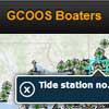 This website provides the one-stop shop for information requested by boaters and fishermen in U.S. Gulf of Mexico waters in a smartphone and tablet friendly format:
Mobile Web: PacIOOS Voyager (provided by PacIOOS)
 The PacIOOS Voyager is a free, interactive, online mapping experience on the familiar Google Maps platform. View, combine, and download current or historical oceanographic observations, predictions, and other geospatial information related to the marine environment and beyond.
On-demand, Current Conditions for Water Data
USGS WaterNow - data delivered directly to your mobile phone or email
Send an email or text message containing a USGS current-conditions gaging site number to WaterNow@usgs.gov and quickly receive a reply with its most recent observation(s).
Details about the USGS WaterNow tool
Real-Time Weather and Water Data App
Smart Buoys by Chesapeake Conservancy
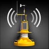 The CBIBS "smart buoys" collect and transmit real-time weather and water data. CBIBS supports the use and management of a healthy Chesapeake Bay by providing the data and information needed to improve safety, enhance the economy, and protect the environment:
National Park Service’s “Chesapeake Explorer” App
 The National Park Service’s (NPS’s) “Chesapeake Explorer” app is available in the iTunes store and in the Android market. Based on their location, the app helps users find national and state parks, trails, and historic sites near them in the Chesapeake Bay watershed. The app helps users match up their interests—like hiking, biking, bird watching—with locations in the area. It contains abundant information on all those places, like location, hours, and other details. The Captain John Smith Chesapeake National Historic Trail and Star-Spangled Banner National Historic Trail—each marked at points by CBIBS buoys—are among the trails highlighted via this app.
Download for: Android
Mobile Websites and Apps from NOAA's National Ocean Service (NOS)
 A compilation of ocean and coast-related mobile websites and free applications produced by or in partnership with National Oceanic and Atmospheric Administration, NOAA.